
Moving Melton
Transport Prospectus 2022
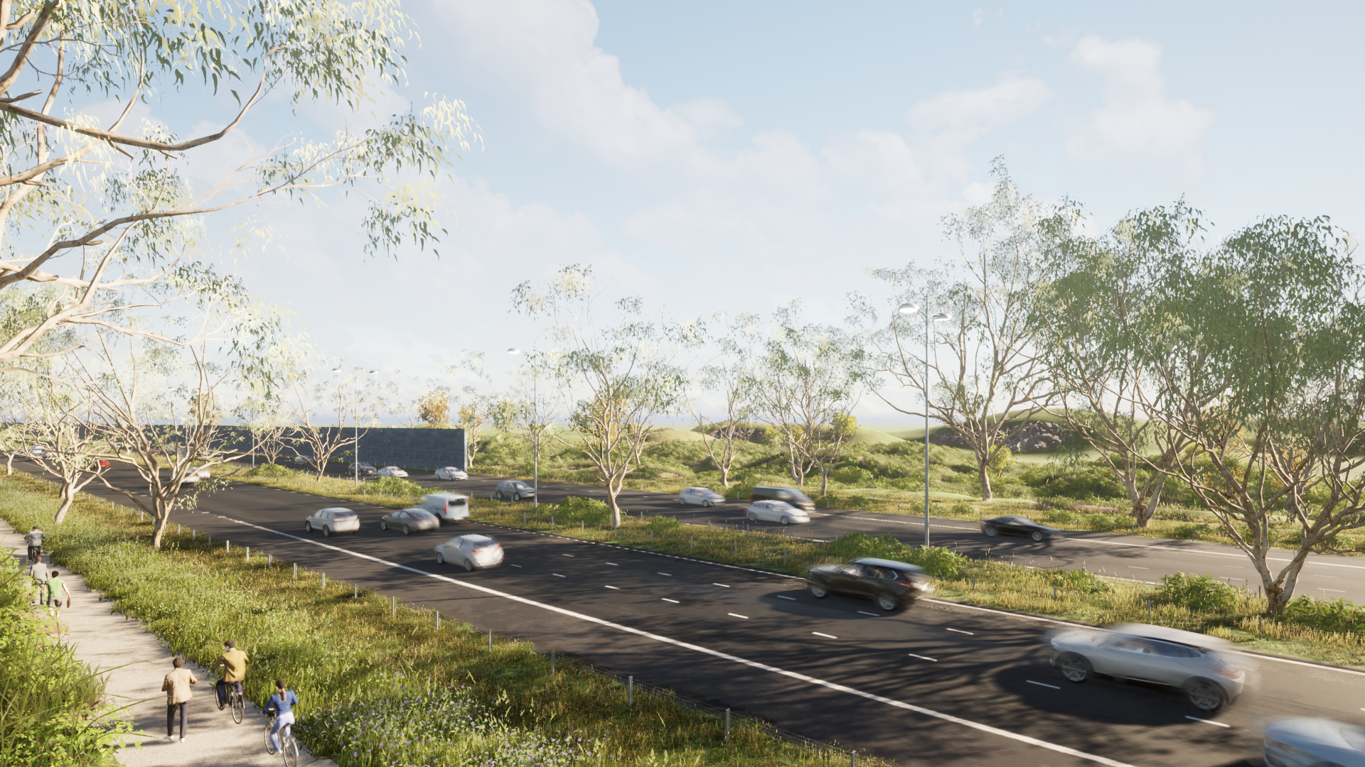
Western Highway: Urbanisation, additional lanes and interchange upgrades
The Western Highway is the main road between Melbourne, Ballarat and onto Adelaide and Perth, and the second largest freight carrier of any national highway, carrying more than 5,400 trucks a day. It is an aged and rural-standard highway with direct property accesses and at-grade interchanges at numerous points. The lack of interchanges and overpasses present a significant safety risk to road users.
Congestion
Western Highway between the M80 ring road and Bulmans Road is estimated to carry over 86,000 vehicles per day. Traffic modelling commissioned by Council indicates that this will increase to over 110,000 vehicles per day by 2031. Traffic is often at standstill at multiple interchanges in peak times as drivers attempt to enter or exit the highway.
Population
280,000 new residents are expected to be added along the Western Highway between Melton and Burnside by 2051. Planning approval for seven additional residential suburbs directly adjacent to the Western Highway will see an estimated 200,000 residents move in by 2051 and a further five Precinct Structure Plans are yet to be prepared, which are expected to include 80,000 people.
Solution
Upgrade to urban freeway standard from Melton to Deer Park, with additional lanes and upgraded interchanges
New pedestrian and cycling path along the Western Highway
Economic benefits
Independent analysis by Clarity Consult, based on the Melton Integrated Transport Model, found that the upgrade of the Western Highway would see a positive Benefit Cost Ratio of 1.08.
This means the total benefits of the project over 30 years outweigh the cost by 1.08 to 1.
The estimated project cost of $1.3 billion will see a total economic benefit of $1.4 billion.
Over 30 years this figure includes:
343,000 hours of travel time saved
37,000 tonnes of greenhouse gases saved
18% reduction in crashes or 170 less crashes
• Project design
• Traffic projections at 2041
• Artist’s render of completed project
• Project benefits
Bulmans Road Interchange
Bulmans Road crosses over the Western Freeway meaning local residents have to drive long distances to access the freeway at already congested interchanges.
A new diamond interchange would take pressure off existing access points to the Western Highway and reduce congestion, it would better connect the fast-growing communities of Melton West and Brookfield.
• A new diamond interchange at Bulmans Road
• Traffic projections at 2041
• Artist’s render of completed project
Ferris Road interchange is single lane each way with dangerous merging and limited active transport options.
In the five-year period between 2015 and 2019 (pre-COVID), there were 12 traffic accidents recorded on Ferris Road at the interchange including one fatality, three serious crashes and 14 other injuries.
Ferris Road is currently estimated to carry over 17,000 vehicles per day and traffic modelling commissioned by Council indicates that this will increase to over 28,710 vehicles per day by 2031.
Solution
Building a new bridge over the Western Highway to create two lanes each way on Ferris Road with separated active transport lanes will help reduce congestion and improve safety at this busy intersection
Ferris Road Interchange
• Ferris Road interchange upgraded with additional lanes
• Traffic projections at 2041
• Artist’s render of completed project
Mount Cottrell Road intersection is a dangerous at-grade intersection to the Western Highway in a 110km zone, with access to only the outbound lanes, resulting in the need for residents to travel to the Ferris Road interchange and then u-turn back onto the freeway to drive to the city.
Solution
Upgrading the intersection to a half-diamond interchange will improve safety and better connect growing suburbs such as Thornhill Park and Grangefields
Mount Cottrell Road Interchange
• Mount Cottrell Road intersection upgraded to a half-diamond interchange
• Traffic projections at 2041
• Artist’s render of completed project
Paynes Road Intersection is a dangerous at-grade intersection to the Western Highway.
Solution
A new overpass at Paynes Road will connect the growing suburbs south of the Western Freeway to the growing suburbs located north off the Western Freeway. The overpass is required to connect the future residents of Grangefields to the future railway station at Thornhill Park
Paynes Road Overpass
• Paynes Road intersection upgraded to a full-diamond interchange
• Artist’s render of completed project
Leakes Road interchange is single lane each way with limited active transport options.
Leakes Road carries approximately 4,500 vehicles per day and traffic modelling commissioned by Council indicates that this will increase to over 22,700 vehicles per day by 2031.
44,000 new residents are expected to move into the area by 2051.
Solution
A new bridge will be constructed over the Western Highway to create two lanes each way on Leakes Road with separated active transport lanes will help reduce congestion and improve safety at this busy intersection.
Leakes Road will be closed at the Ballarat Rail Line and a new arterial road, named Rockbank Road, will be grade separated from the Ballarat Rail Line and constructed from the Western Highway to the west of the future Rockbank town centre
Leakes Road Interchange and New Rockbank Road Alignment
• Project design
• Traffic projections at 2041
Hopkins Road currently carries approximately 28,000 vehicles per day and traffic modelling commissioned by Council indicates that this will increase to over 51,000 vehicles per day by 2031.
In the five-year period between 2015 and 2019 (pre-COVID), there were 16 traffic accidents recorded at the Hopkins Road interchange, including six serious crashes. In total, 10 people have been injured while using this piece of road in the last five years.
68,000 new residents are expected to be added near Hopkins Road by 2051.
Over 20,000 jobs are expected to be created at industrial zones near Hopkins Road including the Melbourne Business Park, creating even more congestion.
Solution
Upgrading the interchange with additional lanes and active transport corridors will reduce congestion, support industry and make the intersection safer
Hopkins Road Interchange
• Hopkins Road interchange upgraded with additional lanes
• Traffic projections at 2041
Christies Road connects Caroline Springs with its train station and industry.
Christies Road, south of Ballarat Road, currently carries approximately 22,300 vehicles per day and traffic modelling commissioned by Council indicates that this will increase to over 28,500 vehicles per day by 2031.
In the five-year period between 2015 and 2019 (pre-COVID), there were 18 traffic accidents recorded on the Christies Road between Ballarat Road and Caroline Station, including four serious crashes.
The commercial Dexus estate next to Caroline Springs station will ultimately be home to as much as 400,000 sq m of commercial and industrial property. Amazon, Myer, Scalzo Foods, Electrolux,and Hello Fresh have all moved into the estate.
Solution
Duplication of Christies Road from Ballarat Road to Caroline Springs Station, additional interchange ramps to the Western Highway and a new pedestrian and cycling path
Christies Road Interchange
• Christies Road interchange upgraded
• Traffic projections at 2041