
Moving Melton
Transport Prospectus 2022
Council Major Road Projects
As a designated Urban Growth Area, there are a series of roads that are the responsibility of developers and Melton City Council to deliver. Upgrading our local roads will remove short trips from arterial roads reducing congestion and better connect our communities. We have identified 11 local roads to be urbanised, upgraded or newly constructed.
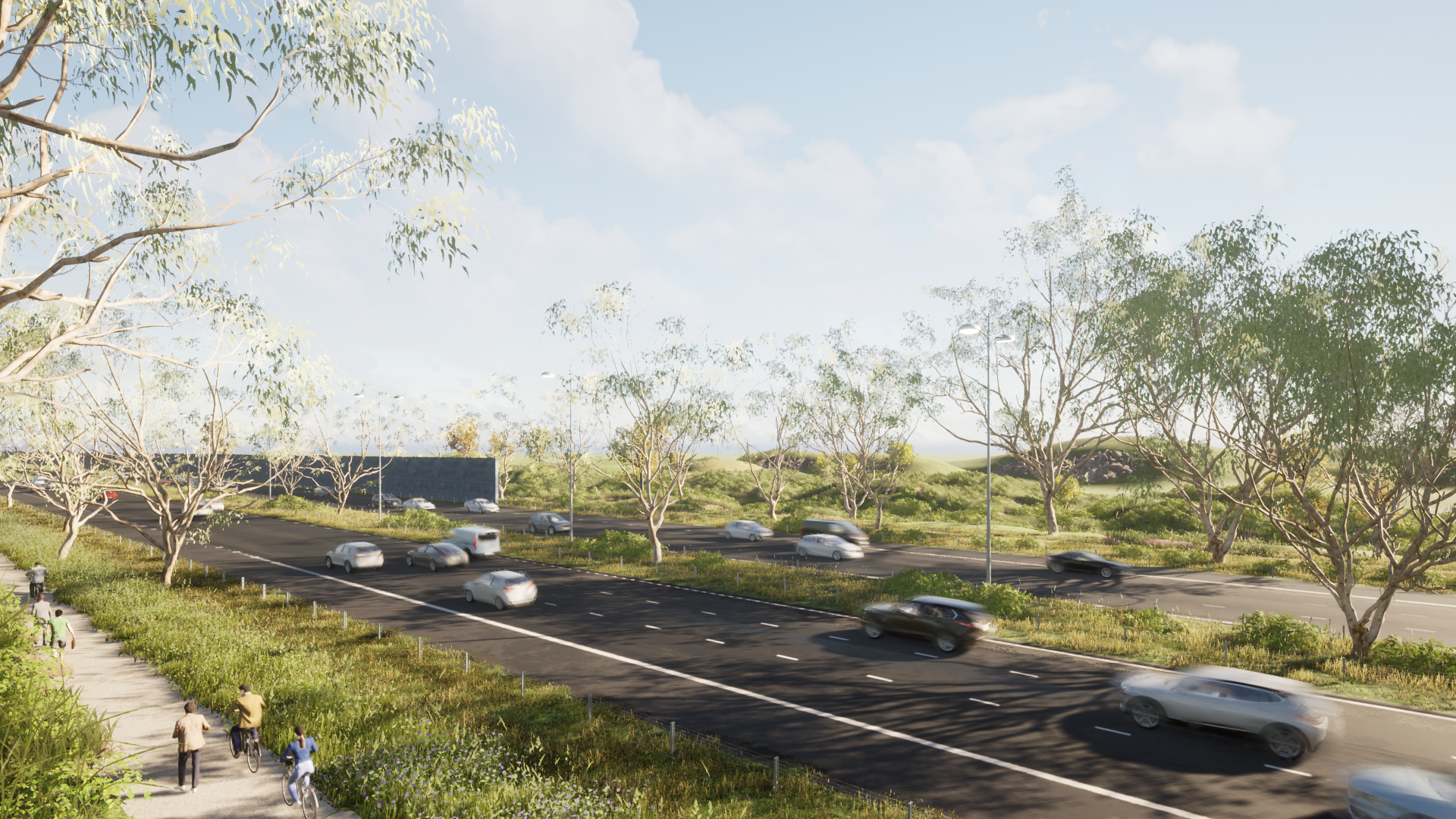
Ferris Road
Current conditions
Ferris Road is a duplicated rural standard road from the Western Highway to Abey Road with no active transport options. South of Abey Road the road is single lane each way rural standard road with no active transport options. The road discontinues at Alfred Road and does not connect to Strathtulloh.
Congestion
Ferris Road is currently estimated to carry over 17,000 vehicles per day and traffic modelling commissioned by Council indicates that this will increase to over 28,710 vehicles per day by 2031.
Population
31,087 people are expected to move into the Cobblebank and Strathtulloh area by 2051 as the population is projected to grow from 10,308 today to 41,395.
Solution
Urbanisation and duplication of Ferris Road from Western Hwy to Bridge Road, construction of single urbanised carriageway from Bridge Road to future east west arterial road with new signalised intersections and pedestrian and cycling path on both sides.
Delivery
Various parts of Ferris Road are already completed. The remainder of Ferris Road is planned to be delivered in conjunction with Level Crossing Removal and Melton Hospital projects in the short to medium term.
• Project design
• Artist’s render of completed project
Current conditions
Plumpton Road is single lane each way of a rural standard with no active transport options or signalised intersections.
Population
56,635 new residents are expected to move into the area near Plumpton Road with a total population of 75,104 by 2051.
Solution
Urbanised single lane each way between Melton Highway and Taylors Road with new signalised intersections at Melton Highway, Tarletons Road and Taylors Road, and pedestrian and cycling path on both sides.
Delivery
Works are already occurring on various development fronts along Plumpton Road. This project is planned to be delivered in conjunction with various developers in medium to long term.
Plumpton Road
• Project design
• Artist’s render of completed project
Current conditions
Thornhill Park, a growing community situated between Mount Cottrell Road and Paynes Road, south of the Western Highway, can only access employment, services and necessities via the Western Highway heading west, or by using rural roads such as Mount Cottrell Road and Alfred Road.
Population
19,424 new residents are expected to be added to Thornhill Park as the population is projected to grow from 7,044 today to 26,468 by 2051.
Solution
Constructing the new single lane each way urbanised road, Shogaki Drive, with signalised intersections at Ferris Road and Mount Cottrell Road and pedestrian and cycling path on both sides. This will link the community of Thornhill Park directly to Cobblebank.
Delivery
The road reservation land for Shokagi Drive is owned by private enterprise. This project is planned to be delivered by council in the short to medium term.
Shogaki Drive
• Project design
• Artist’s render of completed project
Current conditions
Sinclairs Road is single lane each way and of a rural standard with no active transport options.
Population
31,087 people are expected to move into the Cobblebank and Strathtulloh area as the population is projected to grow from 10,308 today to 41,395 by 2051.
Solution
Single urbanised carriageway from Taylors Road to Neale Road new signalised intersections at Taylors Road and Neale Road with pedestrian and cycling path on both sides.
Delivery
Works are already occurring on various development fronts along Sinclairs Road. Council has committed to fund a bridge crossing at Kororoit Creek as well as signalised intersection on Taylors and Sinclairs Roads. The remainder of Sinclairs Road is planned to be delivered in conjunction with various developers in medium to long term.
Sinclairs Road
• Project design
• Artist’s render of completed project
Current conditions
Mount Cottrell Road is single lane each way from the Western Highway to Griegs Road, and is a mixture of urbanised, rural and unsealed road sections, with inconsistent active transport connections.
Mt Cottrell Road

• Mount Cottrell Road with urbanised sections in green, rural sections in yellow, and an unsealed section in red.
Population
Over 50,000 new residents are expected to move into this area by 2051.
Solution
Mount Cottrell Road to be upgraded to an urbanised single lane road each way, signalised intersection at Alfred Road, roundabout at Greigs Road with pedestrian and cycling path on both sides.
Delivery
Council has committed funds to provide an interim seal at the unsealed section of the Mt Cottrell Road. The remainder of the project including urbanisation and shared paths will be delivered in conjunction with various developers in medium to long term.
• Project design
• Artist’s render of completed project
Current conditions
Alfred Road is single lane each way between Ferris Road and Mount Cottrell Road but changes from urbanised to rural treatment without any active transport connections.
Alfred Road

• Alfred Road with urbanised sections in green and rural sections in yellow
Population
31,087 people are expected to move into the Cobblebank and Strathtulloh area by 2051 as the population is projected to grow from 10,308 today to 41,395.
Solution
Urbanisation of Alfred Road between Ferris Road and Mount Cottrell Road with new signalised intersections at Ferris Road and Mount Cottrell Road and pedestrian and cycling path on both sides.
Delivery
Alfred Road is currently fully sealed however further urbanisation and creation of pedestrian and cycling network will be delivered by various developers in the short to medium term.
• Project design
• Artist’s render of completed project
Current conditions
Paynes Road is single lane each way and of a rural standard between the Melton rail line and Griegs Road.
Population
19,424 new residents are expected to be added to Thornhill Park by 2051 as the population is projected to grow from 7,044 today to 26,468.
Solution
Urbanised single lane each way from south of Western rail line to Greigs Road with new signalised intersection at Greigs Road and pedestrian and cycling path on both sides.
Delivery
This project is planned to be delivered in conjunction with various developers in medium term to long term.
Paynes Road
• Project design
• Artist’s render of completed project
Current conditions
Leakes Road is single lane each way and a mixture of rural and urban standard road with limited active transport options.
Congestion
Leakes Road carries approximately 4,500 vehicles per day and traffic modelling commissioned by Council indicates that this will increase to over 22,700 vehicles per day by 2031.
Population
23,573 residents are expected to move into the Rockbank and Fieldstone area by 2051.
Solution
Urbanisation of Leakes Road from the Melton rail line to Griegs Road with an off road cycling path and footpaths on both sides.
Delivery
This project is 80 percent completed by developers and the remainder 20 percent is planned to be delivered by the Rockbank town centre developer in short to medium term.
Leakes Road
• Project design
• Artist’s render of completed project
Current conditions
Exford Road is single lane each way and of a rural standard with no active transport options.
Population
7,973 new residents are expected to be added to Weir Views as the population is projected to grow from 5,229 today to 13,202 by 2051.
Solution
Single lane each way urbanised from Opalia shopping centre to Greigs Road with new signalised intersections, roundabout and pedestrian and cycling path on both sides.
Delivery
This project is planned to be delivered in conjunction with various developers in medium to long term.
Exford Road (Weir Views)
• Project design
• Artist’s render of completed project
Current conditions
Greigs Road is single lane each way of a rural standard with no active transport options and no signalised intersections even though it carries a significant amount of traffic.
Population
Over 100,000 new residents are expected to move into the area served by Griegs Road with a total population of 134,499 by 2051.
Solution
Urbanised single lane each way with connection to the new Grand Boulevard between Hopkins Road and Mount Cottrell Road. Five signalised intersections and two roundabouts with pedestrian and cycling path on both sides.
Delivery
Works are already occurring on various development fronts along Griegs Road. The remainder of the project is planned to be delivered in conjunction with various developers in medium to long term.
Greigs Road
• Project design
• Artist’s render of completed project
Current conditions
Rockbank Middle Road is an urbanised road that varies between single lane and duplicated each way and without a fully connected pedestrian or cycling path.
Population
7,750 people are expected to move into Deanside near Rockbank Middle Road which is expected to grow from 732 today to 8,482 by 2051. 20,296 people live in Caroline Springs now and this is expected to remain stable.
Solution
Urbanisation and duplication between Clarke Road and Westwood Drive, new signalised intersection at Caroline Springs Boulevard and three roundabouts with pedestrian and cycling path on both sides.
Delivery
This project is planned to be delivered by council in the medium to long term.
Rockbank Middle Road
• Project design
• Artist’s render of completed project